The Offshore Oil drilling frontier is moving into evermore challenging environments all the time (ultra-deep water, sub-salt / sub-basalt basins).
Thus it becomes increasingly challenging to image the targets with conventional (mainly seismic) methods alone.
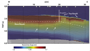
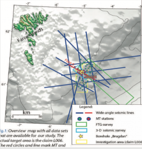
Although this problem has been recognized for a long time, till today very few technologies and methods are available to not just evaluate the different data sets in parallel but to integrate the different geophysical data sets from the beginning.
CEI knows how to do this because we have already done it, successfully and we can prove it

A Sophisticated Technology

Financial Implications
- Reduced risk for exploration or (re)appraisal
Improved well locations and depth to target constraints. - Extension of field life span by discovery of overlooked reservoir compartments
- 4D by just acquiring inexpensive CSEM data instead of expensive 3D seismic data

A Simultaneous Evaluation
of different geophysical data sets reduces exploration and appraisal risks. This means lower drilling costs (multi-physics images are consistent across the different data sets). This results in better characterization of pore fill, reservoir properties, and last but not least geometries.
The Application Field of simultaneous Integration
- Exploration in complex geological areas
- Re-appraisal of existing developments
- 4D monitoring:
- of producing fields
- of carbon capture and storage safety
- New marine geophysical frontiers: offshore ground water, offshore mining
- Exploration in complex geological areasRe-appraisal of existing developments4D monitoring:
- of producing fields
- of carbon capture and storage safetyNew marine geo
physical frontiers: offshore ground water, offshore mining

Where we make a difference and help your company
- Reprocessing of existing data for a new and improved look at the geological target, e.g. reservoir, prospect
-
Validation of existing joint inversion studies
-
Modeling studies for optimal survey design for upcoming joint inversion studies including 4D studies
-
Joint interpretation of complementary single-method geophysical and geological data sets of carbon capture and storage safety
-
New marine geophysical frontiers: offshore ground water, offshore mining
-
We are close to research and delivery a serious critical opinion, never a marketing gimmick.